Severe weather forecast for
late Saturday, early Sunday
Published 9:57 am Friday, March 14, 2025
MOULTRIE – The National Weather Service, in Tallahassee, forecasts severe storms to arrive in this area late Saturday into early Sunday.
Colquitt County Emergency Management Director Justin Cox, said via email, “This squall line will have some severe weather and a possibility of some embedded tornadoes that could be EF2+ and track very long paths. Please make your preparations soon and have multiple ways to get weather alerts.”
He also encouraged residents to use CodeRED. This is a mass notification system that sends telephone calls, text messages, emails and posts to social media. It alerts subscribers about emergency situations in their area.
Residents of Colquitt County can sign-up for the free CodeRed alert system on the County’s website.
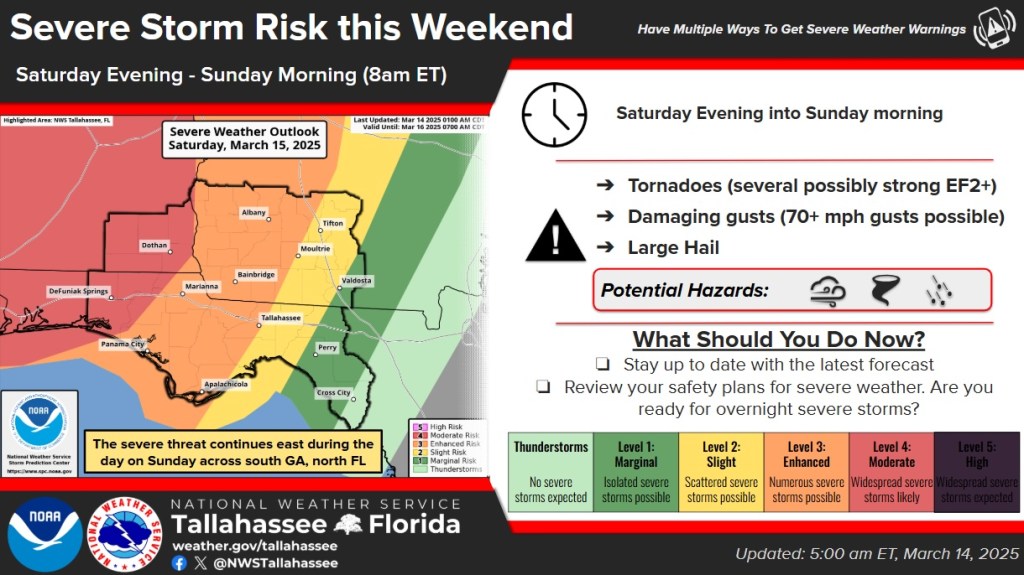
According to the service, there is an Enhanced Risk (level 3 of 5) for areas eastward to Apalachicola, Tallahassee and Moultrie. The forecast states the severe storms may arrive on the western border of this area sometime late Saturday evening.
The potential impacts are, as Cox said, long track tornadoes, which are especially dangerous due to the overnight timing of the arrival of the storm. Also, wind gusts in excess of 60 to 70 mph, large hail and heavy rainfall.
“While areas outlooked in the moderate risk have highest chances for significant severe weather, everyone from roughly Tifton, Tallahassee, Apalachicola and west have the potential to see strong (EF2+) tornadoes and strong damaging winds,” the service also stated.
Expect breezy conditions ahead of the storms and, also, a cold front on Saturday and Saturday night.
The storms are forecast to push eastward through the area overnight and into the morning hours on Sunday, stated the NWS update.
