Weather Service predicts storms, heavy rain this week
Published 6:30 pm Monday, March 7, 2022
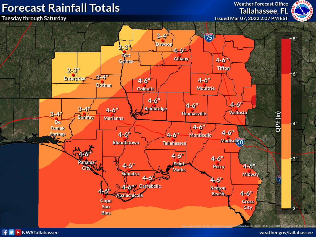
- The National Weather Service's Tallahassee office issued a brief that predicts heavy rainfall this week. It expects 4-6 inches of rain in Colquitt County between Tuesday and Saturday.
MOULTRIE, Ga. — Late last week the National Weather Service was warning about the potential for wildfires because the weather was so dry — a potential that’s been realized in the Florida Panhandle.
Today, the NWS is worried about flooding.
Trending
According to a map that accompanied a brief from the NWS office in Tallahassee, Colquitt County can expect 4 to 6 inches of rain between Tuesday and Saturday from a series of storms rumbling across the region.
“A transition into a pattern supporting rounds of strong or severe thunderstorms, heavy rain, and perhaps some flooding will first set up on Wednesday,” the NWS notice said. “This pattern will continue until about Saturday. The highest severe and flooding threat will come around Friday night and Saturday.”
The weather service predicted a front would turn stationary over South Georgia/North Florida on Wednesday then waver around on Thursday and Friday.
“The air mass will become extremely moist for this time of year,” the brief said, “and quick-moving upper impulses will support strong and possibly severe thunderstorms at almost any time.”
A much stronger cold front will accelerate across the area around Friday night and Saturday, the NWS said. This is likely to bring the week’s greatest risk of severe thunderstorms and the heaviest round of rain.
After the front passes through, much colder temperatures are expected.
Trending
The NWS Weather Prediction Center has placed areas northwest of an Apalachicola-to-Valdosta line in a marginal risk for excessive rainfall on Wednesday and Wednesday night. Colquitt County lies northwest of that line, as does most of the rest of Southwest Georgia. Marginal risk is the lowest on the NWS’s four-point scale.