‘Enhanced’ risk of severe weather Friday into Saturday
Published 5:58 pm Thursday, March 10, 2022
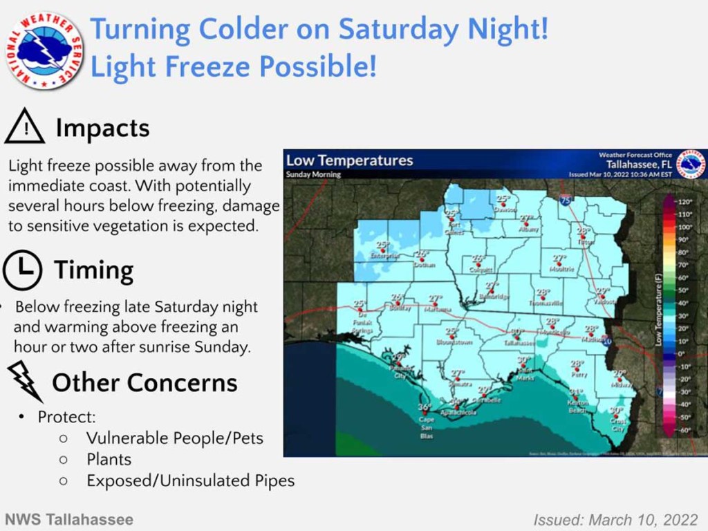
- Freeze coming Saturday night
MOULTRIE, Ga. — Colquitt County avoided most of the severe weather that had been forecast for Wednesday, but meteorologists expect Friday and Friday night to be even worse than they had previously thought.
A notice from Justin Cox, Colquitt County’s emergency management director, on Thursday afternoon warned of storms rolling in Friday afternoon and possibly continuing through the night.
“The severe weather event anticipated to impact Colquitt County and the surrounding areas has been upgraded to an ‘enhanced’ risk (3 out of 5) for Friday evening into Saturday morning,” Cox wrote in an email to The Observer. “We are at risk for some severe thunderstorms, 70+ mph wind gusts, and 1 ½ inch to 2 inches more rain on top of what we have already received.
“There is a cold front pushing through that is fueling the weather,” he wrote. “Estimated time of arrival is 3 a.m. to 6 a.m. Saturday for the ‘squall line’ but rain and winds may arrive as early as Friday afternoon and evening.”
Cox said sustained winds on Saturday will remain 20 to 25 miles per hour.
Temperatures will continue to drop through the day and overnight Saturday. Sunday morning’s low is expected to be in the low to mid 20s, Cox said, with wind chills in the teens. He urged everyone to take care of people who can’t look after themselves as well as pets that could be hurt by the cold temperatures and water pipes that could freeze.
The National Weather Service’s afternoon briefing, which Cox shared information from, said isolated tornadoes, damaging winds and hail are possible with an initial wave of storms Friday afternoon and even moreso as the squall line moves through the area.
The NWS noted a 15% probability of a tornado but a 30% chance of damaging wind, and it said the greater risk for damaging wind is after midnight Friday going into Saturday.