Deadly tornadoes spurred advances in science, emergency preparations
Published 12:04 pm Saturday, May 4, 2024

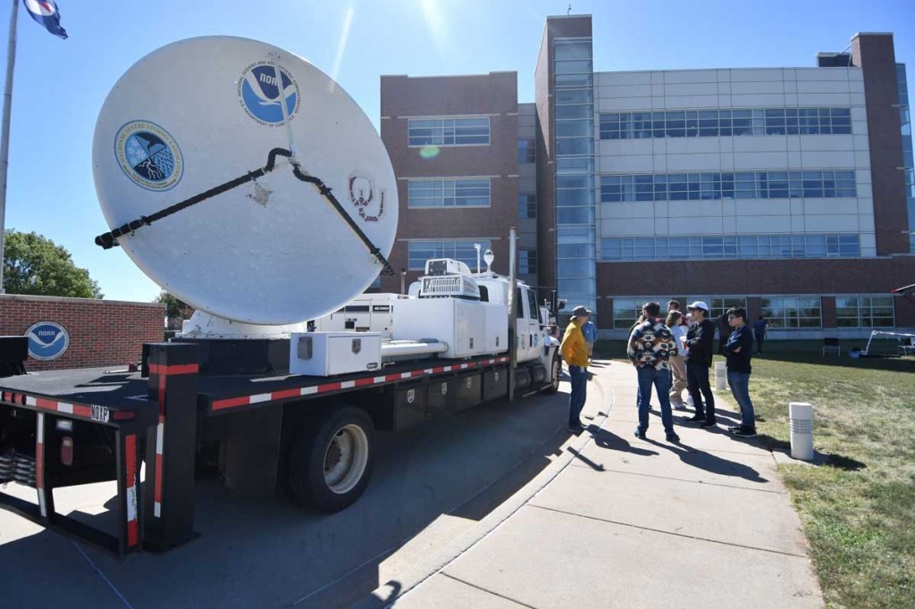
- Visitors look at a radar dish during the Weather Festival, Saturday, Oct. 14, 2023, at the National Weather Center. The event featured many weather-related organizations, such as the National Weather Service, Oklahoma Mesonet, Storm Prediction Center, and broadcast meteorologists from local news channels. (Kyle Phillips / The Transcript)
NORMAN, Oklahoma – Twenty-five years ago, meteorologists used every tool at their disposal to track an exceptionally violent tornado that ripped through central Oklahoma. Now, the situation has changed.
The technology of the time helped meteorologists warn residents — preventing hundreds of additional deaths, by some estimates. But in the years since, that technology has transformed, giving meteorologists more real-time data at their disposal than they’ve ever had before.
Trending
On the morning of May 3, 1999, the Storm Prediction Center issued a slight risk of severe thunderstorms for that evening. At about 11 a.m., the SPC elevated the risk to “moderate”; by 4 p.m., the SPC warned of a high risk of severe weather. Now, the SPC can issue elevated risks of severe weather as far as a week in advance.
“The models that we have are just exponentially better than what we had 25 years ago,” said Scott Curl, a senior meteorologist at the Norman Weather Forecasting Office. “They’re so much better, and so much more accurate farther into the future than they were at that point.”
Like today, the meteorologists in 1999 used continuously-updating satellite images to monitor storm systems. According to Harold Brooks, a senior researcher with the National Severe Storms Laboratory, satellite images came in about every five minutes. But the satellite temporarily stopped updating every day at about 4:15 p.m. to take a full scan of the northern hemisphere. On May 3, the satellite took its long scan just as the first storm cells took shape.
“There was a gap of about 10 minutes, 15 minutes when there was no satellite imagery, and that was a little unfortunate,” Brooks said. “When the first U.S. picture came back in at 4:25, bang – tornado watch comes out, because there were storms starting.”
Curl said meteorologists don’t have to worry about gaps in satellite images now.
“We can get pictures every minute from a satellite that’s 240 miles up in the air,” Curl said. “There’s what they call mesosectors, which are really high definition, smaller scale sectors over the United States. If we overlap two of those, we can actually get a satellite picture every 30 seconds.”
Trending
Curl said the popularization of dual-polarimetric radar is particularly helpful in remotely identifying tornadoes, because dual-pol radar can record a tornado debris signature. There’s also convection-allowing models (CAMs), which Curl said help meteorologists forecast severe thunderstorms more accurately.
“There is a distinction between what happened in 1999 and probably what would happen today, and that difference is I think the forecast that was a few hours out — 12 hours out — would have been better today than it was then,” said David Andra, who at the time was a science and operations officer with the Norman Weather Forecasting Office.
Andra, who retired as the meteorologist-in-charge of the Norman Weather Forecasting Office in 2021 after 34 years with the National Weather Service, said modern numerical models are much more exacting now than at the beginning of his career.
“We get a very high resolution, and by that I mean in space and time, small-scale details that are on the order or the processes that develop supercell thunderstorms,” Andra said. “We did not, early on or even in ’99, have direct measures of a forecasted updraft rotation. We have better measurements and forecasts of low level shear than we used to have.”
Curl said in general, the modern models help meteorologists make more accurate forecasts further in advance. But they must know exactly what they’re looking for.
Andra said events like May 3 contribute to research topics and goals for meteorologists; Brooks noted May 3 also contributed to improvements in the ways cities in the metro area respond to storms.
“For future planning purposes, it exposed every little weakness in what were good plans … We thought, ‘Wow, we didn’t think that that could break that way,’ and yeah, it did,” Brooks said.
Brooks said that between the 1995 bombing and the May 3, 1999 tornado, Oklahoma City refined its emergency response plans down to minutiae.
The May 3 tornado challenged notions of the best ways to stay safe from a twister. Three people died while trying to seek shelter under a highway overpass. Five months later, a team of scientists including Brooks presented their conclusion that highway overpasses are inadequate sheltering locations, and instead instructed motorists to leave their vehicles and lie flat in a nearby ditch if unable to seek shelter in a building.
One other takeaway from May 3 was the necessity for a new research facility for the National Oceanic and Atmospheric Administration’s meteorologists, and in his address after arriving to Oklahoma, President Bill Clinton pledged such a facility would be built in Oklahoma.
The NWC now houses many federal, state and University of Oklahoma entities including the Norman Weather Forecasting Office, National Severe Storms Laboratory, Storm Prediction Center, Radar Operations Center, Oklahoma Mesonet and OU College of Atmospheric and Geographic Sciences.
“We had been talking about building and getting everybody together between the university and the federal side for years, and it was like one year, the state would be ready with funding, one year, the federal would be ready with funding, and we couldn’t get everybody together,” Brooks said. “May 3 was the catalyst.”


