Tropical Depression Nine now Hurricane Ian
Published 3:32 pm Monday, September 26, 2022
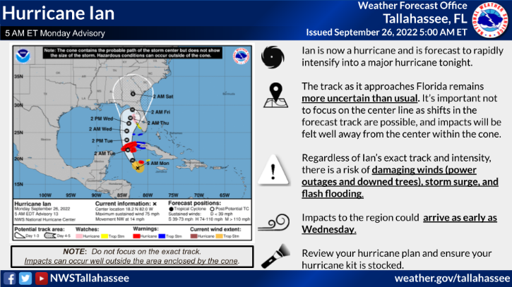
- The National Weather Service’s Tallahassee office posted a map to its website, weather.gov/tae, that showed the storm’s projected path as a “cone of uncertainty.” The cone’s path illustrates where forecasters believe the center of the storm will go but could potentially shift.
MOULTRIE Colquitt County residents should be on alert as Tropical Depression Nine is now Hurricane Ian.
“Ian has strengthened into a hurricane and is expected to become a major hurricane tonight. The uncertainty in the forecast increases as the system moves towards Florida and additional shifts east or west in the forecast track are possible,” according to a National Weather Service’s Tallahassee office.
Trending
As Hurricane Ian moves to the Northwest, it will continue to intensify rapidly today and into Tuesday.
Some impacts from Hurricane Ian could include damaging winds, storm surges and flash flooding. Tropical storm force winds could begin as early as Wednesday.
“This is a very unpredictable track and is changing every hour. We feel that there will be tropical storm level winds, less than 75 mph, and a potential for 4-6” of rain,” Colquitt County Emergency Management Director Justin Cox said in an email after a briefing from the National Weather Service Monday morning.
A storm surge depends on the intensity of the hurricane and large wind field.
The National Weather Service’s Tallahassee office posted a map to its website, weather.gov/tae, that showed the storm’s projected path as a “cone of uncertainty.”
The cone’s path illustrates where forecasters believe the center of the storm will go but could potentially shift.
Trending
The NWS said it’s important for residents to not focus on the center of the storm because impacts will be felt well away from the center within the cone.
A left shift in the track would lead to more rainfall while a more eastward track would lead to less rainfall.
Gov. Brian Kemp told the Capitol Beat News Service, “I urge my fellow Georgians to monitor this storm as it evolves and calmly take the necessary precautions to keep their families and neighbors safe, if the storm continues to intensify.”
Kemp said, “Throughout the week, I will work closely with [the Georgia Emergency Management and Homeland Security Agency], the weather service, public safety organizations, and others to ensure we leave nothing to chance.”
The governor’s office and emergency management officials are monitoring the path of the storm and will provide updates when appropriate.
Residents should also be on alert for local event postponements or location changes.
The Colquitt County School District has also rescheduled and postponed several homecoming activities and events.
For information and tips on how to prepare for a hurricane, refer to the Georgia Emergency Management and Homeland Security website, www.gema.georgia.gov.