Senate proposal shifts some Republican counties into Democrat districts
Published 2:00 pm Thursday, November 4, 2021
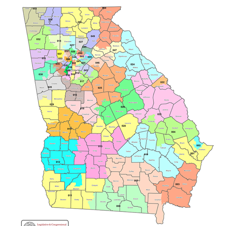
- Georgia's current Senate district map
ATLANTA – Georgia Sen. John Kennedy expects to have the Senate’s new district map approved Friday.
“I want everyone to listen … we’ve heard a lot of good valuable input from around the state,” said Kennedy, chair of the state Senate reapportionment and redistricting committee.
Georgia’s population grew by more than 1 million, or 10%, since the last redistricting cycle in 2011. The 2020 census shows that Georgia’s white population is decreasing while minority populations have increased.
Black population increased by 12.5%, making up 31% or 3.32 million of the state; the Hispanic population increased by nearly 2% by 269,768 during the last 10 years and Asians had the largest increase at 52.3% according to 2020 Census data.
“We had to look at population shifts within the state. We’ve had counties that have lost huge percentages of their population so you have to work those in the mix so it is a fairly difficult process,” House Speaker David Ralston, R-Blue Ridge, said. “I think it’s no secret that Republicans are stronger in rural Georgia than perhaps they are in metro areas and that’s where much of the population loss has occurred so we have to account for that. So I’m sure that means that some of our Republican colleagues may end up getting left behind and that’s a tough part of this thing.”
Republicans largely control the state legislature. Thirty-four of 56 Senate districts are currently controlled by Republicans and 103 of 180 House districts are controlled by Republicans. The makeup of the redistricting and reapportionment committees are similar.
Georgia’s special legislative session convened Wednesday to review the new district maps for Georgia’s House, Senate and congressional districts. The special session to approve new maps could go through Thanksgiving, legislators say.
According to districting guidelines based on populations, each of the state’s 56 Senate districts should include an estimated 191,294 residents; Georgia’s 180 House districts should include estimated 59,000 residents and the state’s congressional districts should include 755,136 residents.
In general the proposed map appears clean up district lines along county board. CNHI looked at proposed Senate districts included in its coverage areas, based on an interactive map developed by watchdog groups Fair Count and the Center for Urban Research:
Senate District 8
Thomas County and Brooks County would be removed from this South Georgia district at its western border, according to the Senate map proposal. The new western district lines would begin along the Lowndes County and Brooks County border and the district’s northern and eastern borders would be extended to include all of Atkinson and Pierce counties, and a majority of Ware County.
The proposal estimates a population of 192,396, 40.5% of them minorities, down from 44% 10 years ago.
Senate District 11
In the district proposal, there is an apparent shift in demographics to shift party lines.The Senate’s map proposal reduces its northern border to begin at the Colquitt County line and extends the border to Cook County. The proposal would no longer split Thomas County and include all Thomas and extend to all of Brooks County to the southeast.
The proposal removes the half of Mitchell County at the north and removes Early and Miller counties from the northwest border.
A map comparison shows that the removed areas will be moved into a new Senate district—District 12, one of the only Democratic and majority Black districts in South Georgia, which according to the proposal would be 65% minority.
Just less than 190,000 people are estimated in the District 11 proposal, to include 42.8% non-white.
Senate District 13
District 13 in South Georgia looks to remain an all-Republican-leaning district, according to the proposal.
It suggests removing northern areas including all of Dooly, Sumter, Wilcox and Dodge counties, and instead extending the district’s eastern borders at Tift and Turner County to include all of Berrien and Irwin counties, and parts of Coffee and Ben Hill counties.
The proposal shows a population of just more than 189,000 people, 37% of them minority.
Senate District 25
The largely Republican district sits within the middle Georgia area and includes all of Baldwin County, the only Democratic-leaning county in the district.
The proposal suggests completely removing Greene and Morgan counties, and its portion of Watson County at its northern border and adding them to a district that includes parts of southeast Henry County, which flipped to a Democratic county in the 2020 elections. The committee proposes taking in some of the south Henry County areas.
The proposal also suggests extending south to include all of Jones County and a small area of Macon-Bibb County, a Democratic voting county. Jones County sits between the two Democratic counties.
More than 191,000 people are estimated to be included in the new district, increasing the minority population from 35.5% to 40.6%.
Senate District 54
The Republican district in north Georgia district includes Whitfield County and does not appear to propose a drastic change.
The redistricting committee proposes removing its portion of Pickens County from its southeastern boarder, and including more of Gordon County at its southwestern border.
The proposal estimates more that 192,000 residents and a largely unchanged shift in demographics. The proposed minority population is estimated at 32.2%, up from 30.1% 10 years ago.