Fred to make landfall today
Published 12:10 pm Monday, August 16, 2021
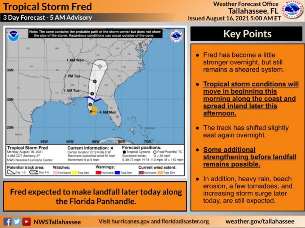
- Tropical Storm Fred
MOULTRIE, Ga. — Tropical Storm Fred is continuing to strengthen off the Florida coast, where forecasters predict it will make landfall by this evening.
Air Force Reserve Hurricane Hunter aircraft determined that Fred’s maximum sustained winds increased to nearly 60 mph and that the tropical storm was shifting eastward. By 8 a.m. EDT, it was 90 miles south-southwest of Apalachicola, Florida, moving north at 9 mph.
Trending
The U.S. National Hurricane Center said Fred’s main threats are rainfall — anywhere from 4 to 8 inches for Florida’s Big Bend and Panhandle — and storm surge. High water between 3 to 5 feet could enter the area between Indian Pass and the Steinhatchee River, depending on the tide at the time of Fred’s arrival.
While landfall is expected well to the west of Colquitt County, the heaviest rain and strongest winds are on the eastern side of the storm, meteorologists have said.
Colquitt County Emergency Management Director Justin Cox said the county is “still in the path of heavy rainfall (2-3 inches) and some, sporadic, gusty, elevated winds (40-50 mph). We should start feeling the effects around 4-5 p.m. It appears to be an ‘all-nighter’ and moving out early Tuesday.”
A tornado watch was issued about 8:30 a.m. today for Colquitt and nine other Southwest Georgia counties until 8 p.m. tonight.
“This is considered a ‘slight’ risk for southwest Colquitt County and a ‘marginal’ risk for the remainder of the county,” Cox said.
Cox previously expressed concerns about flash flooding and about trees and power poles being blown down because the ground is already saturated from earlier rainfall.
Trending
Meanwhile, Tropical Depression Grace is lashing Haiti with wind and rain days after an earthquake killed more than 1,200 people and left multitudes homeless. Grace started in the same general area as Fred, and earlier forecasts showed it following a similar track. Since then, Grace has moved farther south than Fred did, and current forecasts predict it will cross the Yucatan Peninsula of Mexico late Wednesday or early Thursday then continue westward to hit the Mexican Gulf Coast around Saturday morning.