Tropical depression shifts slightly west; Colquitt County in less danger
Published 6:10 pm Friday, August 13, 2021
- TD Fred
MOULTRIE, Ga. — Colquitt County is not out of the woods yet, but a westward shift in the track of Tropical Depression Fred does have local emergency officials breathing a little easier.
“Fred seems to have a slight westward shift, which is good news for us,” Colquitt County Emergency Management Director Justin Cox said after a briefing from the National Weather Service on Friday. “We are still forecasted to receive some significant rainfall (2” to 3”) and a 10-20% chance of some tropical storm strength winds (30+ mph). Flash flooding and toppled trees due to soaked grounds are a very real possibility.”
Trending
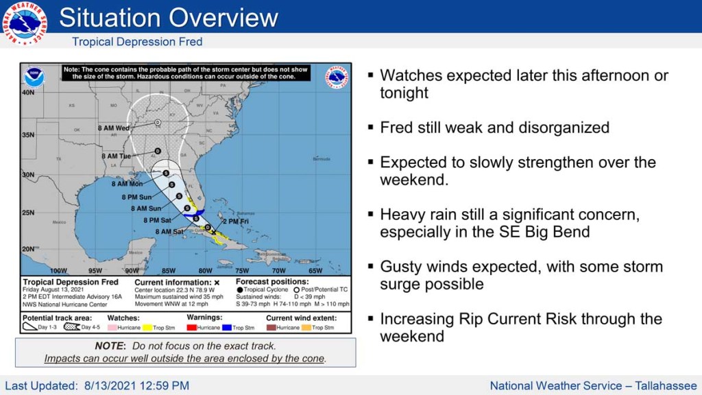
The National Weather Service’s Tallahassee office posted a map to its website, weather.gov/tae, that showed the storm’s projected path as a “cone of uncertainty.” The path depicts where forecasters believe the center of the storm will go. It forms a cone because the farther in the future they’re predicting, the more variation there can be in the storm’s path.
If the storm’s center were to follow the eastern-most edge of the cone of uncertainty shown on the NWS map, it would pass to the west of Colquitt County. But the storm will reach some distance beyond its center, and the NWS website says much of Fred’s impacts will likely be on the eastern side of the center.
Colquitt County officials had considered a meeting Sunday to coordinate storm response, but after Friday’s briefing they decided the meeting wasn’t necessary.
Nonetheless, Cox urged everyone to keep abreast of the weather by weather radio, social media or other communications in case the forecast changes.